

Barrie Administrative Districts Guide
Complete breakdown of Barrie's official administrative districts and neighborhoods
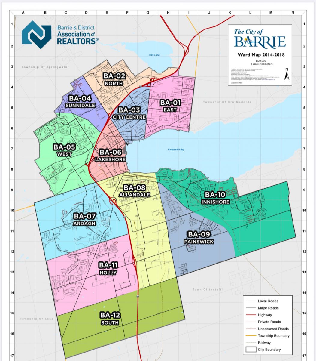
BA-01 (East)
North: Little Lake
East: City Limits
South: Kempenfelt Bay
West: Johnson Street
Neighborhoods:
- Grove Street East
- Johnson's Beach
- Queen's Park
BA-02 (North)
North: City Limits
East: Highway 400
South: Grove Street East
West: Anne Street North
Neighborhoods:
- North Shore
- Heritage Park
- Georgian Drive
BA-03 (City Centre)
North: Grove Street East
East: Johnson Street
South: Kempenfelt Bay
West: Bayfield Street
Neighborhoods:
- Downtown Core
- Memorial Square
- Barrie Marina
BA-04 (Sunnidale)
North: City Limits
East: Anne Street North
South: Dunlop Street West
West: Ferndale Drive
Neighborhoods:
- Sunnidale Park
- Bull Creek
- Anne Street North
BA-05 (West)
North: Dunlop Street West
East: Bayfield Street
South: Kempenfelt Bay
West: Ferndale Drive
Neighborhoods:
- Bayfield North
- Pringle Drive
- Bayshore Drive
BA-06 (Lakeshore)
North: Kempenfelt Drive
East: Bayfield Street
South: Lake Simcoe
West: City Limits
Neighborhoods:
- Lakeshore Drive
- Minet's Point
- Willow Bay
BA-07 (Ardagh)
North: Ferndale Drive
East: Veterans Drive
South: Ardagh Road
West: City Limits
Neighborhoods:
- Ardagh Bluffs
- Holly Community
- Letitia Heights
BA-08 (Northwest)
North: City Limits
East: Highway 400
South: Duckworth Street
West: Anne Street
Neighborhoods:
- Duckworth Plaza
- Livingstone Street East
- Cedar Point
BA-09 (Northeast)
North: Penetanguishene Road
East: City Limits
South: Highway 400
West: St. Vincent Street
Neighborhoods:
- Grove Park
- North Village
- Bayview Drive
BA-10 (Innishore)
North: Mapleview Drive
East: Prince William Way
South: Lake Simcoe
West: Hewitt's Creek
Neighborhoods:
- Royal Pines
- Big Bay Point
- Friday Harbour
BA-11 (Holly)
North: Essa Road
East: Highway 400
South: Mapleview Drive
West: Veterans Drive
Neighborhoods:
- Holly Community
- Maple Ridge
- Essa Road South
BA-12 (South)
North: Mapleview Drive
East: Highway 400
South: City Limits
West: Veterans Drive
Neighborhoods:
- Park Place
- Salem
- Hewitt's Creek
Discover Barrie's Administrative Districts
Barrie's 12 administrative districts create a well-organized mosaic of vibrant communities, each with its own distinct character and amenities. From the bustling City Centre (BA-03) to the waterfront charm of Lakeshore (BA-06), these districts showcase Barrie's diverse residential and commercial landscape.
The northern districts, including BA-01 (East) and BA-02 (North), offer established neighborhoods with excellent accessibility to major highways and amenities. The western districts, encompassing BA-04 (Sunnidale) and BA-05 (West), feature growing communities with a blend of residential developments and green spaces.
Southern districts such as BA-11 (Holly) and BA-12 (South) represent Barrie's expanding horizons, offering newer developments and future growth potential. The waterfront districts, including BA-06 (Lakeshore) and BA-10 (Innishore), provide coveted lakeside living opportunities along the shores of Lake Simcoe.
Each district benefits from Barrie's comprehensive urban planning, featuring well-connected transportation networks, local amenities, and community facilities. Whether you're seeking established neighborhoods, waterfront properties, or emerging communities, Barrie's administrative districts offer diverse options for residents and investors alike.
Explore Barrie's Districts With a Local Expert
Discover the perfect neighborhood for your lifestyle and investment goals with personalized guidance.


